FOREST LOOKOUTS
  • HOME
  • ARKANSAS
    • Abbott Mountain
    • Allen Peak
    • Allison
    • Almond
    • Alpine
    • Artesian
    • Atlanta
    • Banks
    • Bear Knob
    • Bee Mountain
    • Benson
    • Bethel
    • Big Lake
    • Bismarck
    • Black Mountain
    • Blakely
    • Blue Ridge
    • Boat Mountain
    • Boston Mountain
    • Bowden
    • Box Springs
    • Bradley (98)
    • Buck Knob
    • Bucksnort
    • Bud Hill
    • Buena Vista
    • Buffalo
    • Bull Mountain
    • Bull Shoals Mountain
    • Burlington
    • Cane Creek
    • Casa Mountain
    • Cazort
    • Cedar Cabin
    • Cedar Mountain
    • Center
    • Charlotte
    • Cleveland
    • Coleman (Tree)
    • Cominto
    • Compton
    • Cossatot
    • Cove Mountain
    • (Crossett ?)
    • Crossroads
    • Crystal Mountain
    • Deer
    • Devil's Knob
    • Dobbs Spring
    • Dutch Creek
    • Eagle Mountain
    • Eureka Springs
    • Evans Mountain
    • Fairview
    • Fly Gap
    • Forum
    • Fourche Mountain
    • Freck
    • Gaston Mountain
    • Gillham
    • Glenville
    • Goosepond Mountain
    • Green
    • Guy
    • Hardy
    • Harris Mountain
    • High Peak (Signal #2)
    • Holly Springs
    • Horn
    • Iron Mountain
    • Key Hill
    • Magazine
    • Matney Mountain
    • (McNab ?)
    • Moro
    • Muddy Mountain
    • North Fork Pinnacle
    • Oak Mountain
    • Oakland
    • Omaha
    • Ouachita Pinnacle
    • (Pansy ?)
    • (Pinetree ?)
    • Pinnacle Hill
    • Poison Springs
    • Powell Mountain
    • Push Mountain
    • Rich Mountain
    • Round Hill
    • Round Mountain
    • Rushing
    • (Ruth ?)
    • Stone House
    • Swain Mountain
    • Sugarloaf
    • Tall Peak
    • Tar Kiln
    • Turnpike
    • Tyre
    • Velvet Ridge
    • Wedington Mountain
    • Whiskey Peak
    • White Oak Mountain
    • White Rock Mountain
    • Wilmar
    • (Wilton ?)
    • Wolf Pinnacle
  • ILLINOIS
    • ADEN
    • Atwood Hill
    • Bald Knob
    • Bass Hill
    • Benton
    • Big River State Forest
    • Buzzville
    • Crab Orchard
    • Cypress
    • Deputy Hill
    • Dry Hill
    • Forest Glen Forest Preserve
    • Fountain Bluff
    • Hickory Ridge
    • Hicks
    • High Knob
    • Honey School
    • Lively Grove
    • Massac
    • McCormick
    • Melcher Hill
    • New Orient Mine
    • Pere Marquette State Park
    • Peters Creek
    • Pinckneyrville
    • Raum
    • Royalton
    • Sand Ridge State Forest
    • Shawneetown Hills
    • Trail of Tears
    • Trigg
    • Union Forest
    • Water Valley
    • Williams Hill
  • IOWA
    • Yellow River
  • KANSAS
    • Maxwell wildlife area
  • LOUISIANA
    • Abita Springs
    • Aimwell
    • Antonia
    • Belah
    • Brown Paper Company
    • Calhoun
    • Catahoula
    • Clay
    • Clear Creek
    • Colfax
    • D'Arbonne
    • Fairbanks
    • Gardner
    • Gordon
    • Gum Springs
    • Hilly
    • Hood's Mill
    • Kisatchie
    • Leesville
    • Leland
    • Linville
    • Livingston
    • Longview
    • Longville
    • Luna
    • Meridian
    • Merryville
    • Mosley Hill
    • Mount Pleasant
    • Natchitoches
    • No. 1 (Bogalusa)
    • No 2 (Urania)
    • Paul J. Rainey Wildlife Refuge
    • Peason
    • Red Dirt
    • Sikes
    • Springville
    • Sugartown
    • Turkey Creek
    • Turner
    • Vernon
    • Winona
    • Woodworth
  • MINNESOTA
    • Agassiz
    • Ahren's Hill
    • Alida Hill
    • Alton Heights
    • Anchor Hill
    • Angleworm
    • Argus
    • Arrow
    • Arrowhead
    • Ash River
    • Askov
    • Babbitt
    • Badoura
    • Ball Bluff
    • Bankton
    • Bass Lake
    • Bass Lake (M)
    • Bearskin
    • Beauty Lake
    • Bemidji
    • Ben Draper
    • Big Falls
    • Big Meadows
    • Big Sandy (Lake)
    • Birch Hill
    • Birch Knob
    • Birch Lake
    • Birchdale
    • Black Bay
    • Blueberry Hill
    • Borden Lake
    • Boulder Hill
    • Brainerd
    • Buhl
    • Burns Lake
    • Camp No. 1
    • Carlton Peak
    • Cascade
    • Cass Lake
    • Clear River
    • Cloquet
    • Cloquet Valley
    • Coleraine
    • Cotton
    • Cromwell (Skunk Island)
    • Cuyuna
    • Day Lake
    • Deer Lake
    • DeSoto
    • Devilfish
    • Dixon Lake
    • Dorset
    • Drummond
    • Elba
    • Elephant Lake
    • Eliason
    • Ely
    • Emily
    • Farley Hill
    • Fernburg
    • Grand Marias
    • Gull Lake
    • Gunflint
    • Height of Land
    • Hillview
    • Indian Pines
    • Isle Harbor
    • Itasca State Park
    • Jack Pine
    • Jasper Peak
    • Jay Cooke
    • Jesse Lake
    • Kabekona
    • Kabetogama
    • Kekekabic
    • LaSalle
    • Lima
    • Link Lake
    • Little Mantrap
    • Loman
    • Longville.
    • Ludlow
    • Maple Hill
    • Marble Lake
    • Mille Lacs
    • Mt Maude
    • Nickerson
    • Northwest Angle
    • Palisade
    • Pequaywan Lake
    • Pequot Lakes
    • Pickerel
    • Pike
    • Prosper
    • Rail Prairie
    • Sand Dunes
    • Scenic
    • Schley Ranger Station
    • Sioux River
    • Smoky Hills
    • Spider Lake
    • Spirit Lake
    • St. Croix
    • Sugarbush
    • Sullivan Lake
    • Sumac Hill
    • Summit
    • Toad Mountain
    • Vermillion Dam
    • Waskish
    • Wynn Lake
    • Misc. Notes..
  • MISSOURI
    • Adams
    • Asher
    • August A. Busch
    • Avon
    • Baldridge
    • Baldy
    • Beasley Tree
    • Beaufort
    • Beaver
    • Bee
    • Bell Mountain
    • Big Spring
    • Black
    • Blackjack Knob
    • Bloodland
    • Bloomfield
    • Blue Buck
    • Blue Mountain
    • Blueslip
    • Boone (Daniel)
    • Branch
    • Brandsville
    • Braswell
    • Breeze
    • Briar
    • Brooks
    • Brownfield
    • Brushy
    • Buck Mountain
    • Buick
    • Bunker
    • Bunker's Knob
    • Butts
    • Cabool
    • Camdenton
    • Canaan
    • Caney
    • Cappeln
    • Cascade
    • Cedar Creek
    • Center
    • Centerville
    • Climax Springs
    • Coffman
    • Combs
    • Coon
    • Coot Mountain
    • Corn Creek
    • Cottener
    • Crane
    • Crooked
    • Cub
    • Cut
    • Czar
    • Deer Run
    • Dit
    • Dixon
    • Dogtown
    • Dogwood
    • Doniphan
    • Doniphan Water Tower
    • Dora
    • Drake
    • Dupont
    • Eagle
    • Eastwood
    • Elkhorn (Bethpage)
    • Ellsinore
    • Eminence
    • Eugene
    • F-18
    • Fairview
    • Falcon
    • Faro
    • Flat Rock
    • Flatwoods
    • Floyd
    • Forestry Camp
    • Fort Leonard Wood
    • Fox
    • Freeburg
    • Fremont
    • French
    • French Village
    • Ganter
    • Garwood
    • Gentry
    • Gipsy
    • Goodman
    • Grandin
    • Grassy
    • Grassy Mountain
    • Greenley
    • Gulf
    • Gutherie
    • Hartshorn
    • Hercules
    • Higdon
    • High Hill
    • High Place
    • High Point
    • Highway 60
    • Hilda
    • Hilltop
    • Himont
    • Hollister
    • Horn
    • Horton
    • Houston
    • Hunter
    • Hurricane Deck
    • Indian Trail
    • Jay
    • Jenkins
    • Johnson Mountain
    • Joplin
    • Julian
    • Junction
    • Kaiser
    • Kelleter
    • Keltner
    • Keysville
    • King
    • Kirksville
    • Knob Lick
    • Knobview
    • Knotwell
    • Lanagan
    • Leasburg
    • Lebanon
    • Lenox
    • Libertyville
    • Lincoln
    • Lohmer
    • Lone Hill
    • Lone Hill
    • Lone Pine
    • Lonedell
    • Lookout
    • Lost Creek
    • Low Wassie
    • Lutie
    • Lynchburg
    • Macedonia
    • Marcoot
    • Marshfield
    • Mendon
    • Meramec
    • Meta
    • Middle
    • Mineola
    • Montauk
    • Mount Hulda
    • Mountain View
    • Mud Pond Ridge
    • Mudlick Mountain
    • Muilvinia
    • Neosho
    • New Liberty
    • Nottinghill
    • Oak
    • Oates
    • Orchard
    • Old Bartlett
    • Owens
    • Oxly
    • Panther
    • Panther Hill
    • Perry
    • Phillipsburg
    • Pigeon
    • Pike
    • Pilot Knob
    • Pilot Knob
    • Pineview
    • Piney
    • Plad
    • Plots
    • Point (Gibson)
    • Pomona
    • Poplar
    • Possum Trot
    • Potosi
    • Powell
    • Proctor
    • Reeds Spring
    • Reform
    • Refuge
    • Roby
    • Rockwoods
    • Rockview
    • Rocky Mount
    • Rolla Headquarters
    • Romance
    • Rombauer
    • Rosati
    • Rosehill
    • Runge Conservation Center
    • Saunders
    • Sayersbrook Bison Ranch
    • Seever
    • Seymour
    • Shannondale
    • Siloam Springs
    • Sinking Creek
    • Squires
    • Stegall Mountain
    • Sterling
    • Stono Mountain
    • Sugar Camp
    • Sullivan Hill
    • Summersville
    • Sun Ridge
    • Swedeborg
    • Talbert
    • Taum Sauk
    • Tecumseh
    • Texas
    • Thomasville (F)
    • Thomasville (S)
    • Tiff
    • Timber Knob
    • Tram
    • Tribune
    • Turner
    • Tusher
    • Twin Knobs
    • Tywappity
    • Ulman
    • Vada
    • Vichy
    • Vulcan
    • Warrenton
    • Washburn
    • Washington
    • Washington State Park
    • Weldon Springs
    • West Plains
    • Westover
    • Wharton
    • Whitewater
    • Wilderness
    • Williamsville
    • Windy
    • Wolf Mountain
  • OKLAHOMA
    • Bear Mountain
    • Beaver Mountain
    • Big Eagle Mountain
    • Black Fork Mountain
    • Blue Mountain
    • Broken Bow
    • Buffalo Mountain
    • Carnasaw
    • Carter Mountain
    • Cavanal
    • Cloudy
    • Crows Nest
    • Flagpole
    • Flashman
    • Flattop
    • Hee Mountain
    • Jadie
    • Jay
    • Kiamachi
    • Lone Prairie
    • Mount Scott
    • Phillips Mountain
    • Polecat
    • Rose
    • Round Mountain
    • Signal Mountain
    • Sobol
    • Sycamore
    • Tiak
    • Tom
    • Walnut Mountain
    • Winding Stair
  • TEXAS
    • Misc. Notes - Texas
    • Adams Hill
    • Alto
    • Appleby
    • Ariola
    • Arp
    • Barnum
    • Bath
    • Beckville
    • Bird Mountain
    • Bon Wier
    • Bronson
    • Buna
    • Burkeville
    • Cairo Springs
    • Camden
    • Central School
    • Chambers Hill
    • Chester
    • Chireno
    • Chita
    • Church Hill
    • Conroe J.G. Jones State Forest
    • Cushing
    • Cyclone Hill
    • Cypress Lake
    • Daingerfield
    • Deadwood
    • DeKalb
    • Dodge
    • Douglassville
    • Dreka
    • East Mountain
    • East River
    • Elysian Fields
    • Etoile
    • Evadale
    • Fails (Mossy Grove)
    • Farris
    • Fern Lake
    • Fincastle
    • Four Notch
    • Gilmont
    • Grayburg
    • Hallsville
    • Hooks
    • Horton
    • Huntington
    • Hyatt
    • Karnack
    • Kenefick
    • Kirbyville
    • Kountze (early)
    • Kountze
    • Latch
    • Livingston.
    • Love's
    • Lufkin
    • Magnolia
    • Maydelle
    • Moores Grove
    • Moscow
    • Moss Hill
    • Mt. Enterprise
    • Negley
    • Oak Shade
    • Onalaska
    • Ratcliff
    • Risken
    • Rusk
    • Salem
    • Scottsville
    • Shady Grove
    • Soda
    • Splendora
    • Spurger
    • State Forest #1
    • Wakefield
    • Weches
  • WISCONSIN
    • Misc. Notes - Wisconsin
    • Ackley
    • Adams
    • Aniwa
    • Anvil Lake
    • Archibald
    • Bagley
    • Bancroft
    • Barronett
    • Bass Lake.
    • Bayfield
    • Belle Mound
    • Birch Hill.
    • Birchwood
    • Blue Hills
    • Blue Mound
    • Boulder
    • Boulder Lake
    • Bruce Mound
    • Brule
    • Buckeye
    • Carter
    • Cedarville
    • Chetek
    • Connors Lake
    • Consolidated
    • Cranberry Rock
    • Dairyland
    • Danbury
    • Dyracuse
    • Eagle Bluff
    • Elk River
    • Elm City
    • Fifield
    • Flambeau
    • Flambeau Ridge
    • Friendship
    • Fromm
    • Glidden
    • Gordon
    • Greenfield
    • Hiles
    • Hodag
    • Indian Lake
    • Iron River
    • Island Lake
    • Jack Pine
    • Jones Dam
    • Julia
    • Jump River
    • Ladd Creek
    • Ladysmith
    • Lampson
    • Laona
    • Little Switzerland
    • Long Lake
    • Long Mile
    • Lookout Mountain
    • Mellen
    • Middle Inlet
    • Military Hill
    • Monico
    • Morris
    • Mosinee
    • Mountain
    • Necedah
    • Nepco
    • Nettleton
    • Newald
    • North Mound
    • Ogema (Timms Hill)
    • Perkinstown
    • Phillips
    • Pickerel Lake
    • Piehl
    • Pine Lake
    • Pipestone
    • Pleasant Lake
    • Porcupine
    • Quincy Bluff
    • Rock Falls
    • Sand Island
    • Seeley
    • Sentinel Point
    • Seymour
    • South Fork
    • South Pine
    • Smoky Hill
    • Springstead
    • Squirrel Hill
    • Sugar Bush Hill
    • Swen's Bluff
    • Thunder Mtn (Lake)
    • Tigerton
    • Upson
    • Volk Field
    • West Fork
    • Wildcat Mountain
    • Wilson
    • Winter
    • Wisconsin Dells
    • Zenith
  • New Page
MISSOURI LOOKOUTS

PINEY

Phelps County
Mark Twain National Forest
​34N-10W-3

February 7, 1937:  "Plans are being completed for the erection of a temporary lookout tower about three miles southeast of Big Piney, in the Piney ranger district of the Gardner national forest.  They will call for an open 'crows nest' atop a forty foot pine pole.
     The nest, five feet square and with three foot walls, will not be permanently roofed, but will have a canvas covering which can be shifted around to cover the observer and protect the instruments in the basket.
     The nest, fashioned of electrically welded angle iron, has already been built at the Blooming Rose CCC camp, and will soon be taken to its permanent site and hoisted to the top of the pole by tackle.
     Forestry officials state that if this type of look-out proves successful, a large number of them will be constructed over the area before the next fire season."  (The News and Tribune)

November 4, 1938:   "Kenneth Jackson in charge, Joe Turner and Pershing Snodgrass who was recently sent out."   (The Oak Tree - Civilian Conservation Corps newspaper of Company 1732, U.S.F.S. Camp F-9)
​

Picture
Removed

Picture

National Geodetic Survey
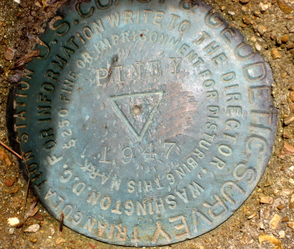
Picture

DESIGNATION - PINEY
PID - HD1044
STATE/COUNTY- MO/PHELPS
COUNTRY - US
USGS QUAD - BIG PINEY (1978)

STATION DESCRIPTION

DESCRIBED BY COAST AND GEODETIC SURVEY 1947 (FRG)
THE STATION IS LOCATED ABOUT 13-1/2 MILES SOUTHEAST OF
WAYNESVILLE, ABOUT 6-1/2 MILES SOUTHEAST OF FT. LEONARD WOOD,
ABOUT 2-1/2 MILES EAST OF THE BIG PINEY RIVER, AT THE PINEY
LOOKOUT TOWER (FOREST SERVICE), IN THE MARK TWAIN NATIONAL
FOREST. IT IS 93 FEET EAST-NORTHEAST OF THE NORTHEAST CORNER OF
THE FOREST SERVICE HOUSE, 34 FEET WEST-NORTHWEST OF A FENCE,
AND 49.37 FEET SOUTHWEST OF THE LOOKOUT TOWER. THE DISK IS
STAMPED PINEY 1947 AND IS SET FLUSH WITH THE GROUND. (NOTE-
THE LOOKOUT TOWER HAS BEEN BLOWN DOWN BUT IT IS TO BE REBUILT
USING THE SAME FOUNDATION AND ANCHOR BOLTS).

TO REACH THE STATION FROM THE JUNCTION OF U.S. HIGHWAY 66 AND
STATE HIGHWAY 17 IN WAYNESVILLE, GO EAST ON HIGHWAY 66 FOR 11.25
MILES TO THE JUNCTION OF COUNTY ROUTE J. TURN RIGHT ON ROUTE
J AND GO 0.1 MILE TO STATION CLEMENTINE 1946 ON THE RIGHT. HERE
TURN RIGHT AND FOLLOW ROUTE J FOR 5.95 MILES TO STATION
SPRINGCREEK ON THE RIGHT. CONTINUE SOUTH FOR 2.15 MILES TO THE
SPRING CREEK POST OFFICE ON THE LEFT. CONTINUE SOUTH, ALONG
THE BANK OF THE RIVER FOR 2.8 MILES TO A FORK. TAKE THE RIGHT
FORK, UP HILL, AND GO 1.95 MILES TO THE FOREST SERVICE HOUSE ON
THE RIGHT AND THE STATION AS DESCRIBED.
​
.
Picture
April 2016 - Courtesy:  Bob Frakes
Picture
Picture
Member:  Forest Fire Lookout Association

Picture