TEXAS LOOKOUTS
ALTO #10
Cherokee County
Texas Forest Service
Texas Forest Service
June 2, 1939: "Tower No. 10, Alto, 5 1/2 miles southeast of Alto." (The Rusk Cherokeean)
February 14, 1946: "During January there occurred in Cherokee County 9 forest fires which burned over 901 acres of forest land. Three fires were reported and suppressed by Forest Patrolman N.W. Foster of the Alto lookout tower, two of which were caused by careless brush burning and other by a careless smoker." (The Rusk Cherokeean)
April 11, 1946: "The forest fire record for March in Cherokee County doubled that of the two previous months of the year. There were during March 34 forest fires which burned over 2694 acres of forest land. Forest patrolman N.W. Foster of the Alto lookout tower handled seven of the fires." (The Rusk Cherokeean)
May 9, 1946: "The forest fire record for April in Cherokee County was fair says M.V. Dunmire, District Forester. There were during April, 5 forest fires which burned over 30 acres of forest land. Forest Patrolman N.W. Foster, of the Alto lookout tower handled one fire." (The Rusk Cherokeean)
January 17, 1952: "Mr. and Mrs. J.A. Benge are moving to Maydelle where Mr. Benge will take over the fire tower there. We regret losing these good people but hope they will be happy in their new home. Mr. Benge has been manager of the Alto fire tower here." (The Alto Herald)
August 2018: Maintenance work was performed.

|
National Geodetic Survey
|

|
DESIGNATION - ALTO
PID - BY2715
STATE/COUNTY- TX/CHEROKEE
COUNTRY - US
USGS QUAD - FOREST (1973)
STATION DESCRIPTION
DESCRIBED BY COAST AND GEODETIC SURVEY 1948 (RLE)
THE STATION IS LOCATED ABOUT 3.0 MILES AIRLINE SOUTHEAST OF
ALTO AND 1.0 MILE EAST OF U.S. HIGHWAY 69 NEAR THE ALTO
LOOKOUT TOWER NO 10 OF THE TEXAS STATE FOREST SERVICE.
IT IS 92 FEET SOUTH OF THE CENTER OF THE LOOKOUT TOWER,
24 FEET EAST OF THE CENTER OF THE DRIVEWAY AROUND THE LOOKOUT
TOWER, 18 FEET SOUTH OF DRIVEWAY AROUND TOWER AND 38 FEET
SOUTH OF GATE IN HEDGE ROW AROUND LOOKOUT TOWER. IT IS STAMPED
ALTO 1948 AND PROJECTS 4 INCHES.
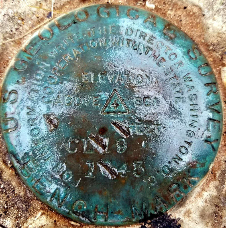
REFERENCE MARK NO 1 IS THE U.S.G.S. BENCH MARK CL 19. IT IS
NORTH OF THE STATION UNDER THE CENTER OF THE LOOKOUT TOWER.
IT IS A STANDARD U.S. GEOLOGICAL SURVEY BENCH MARK SET IN
A 10 INCH CIRCULAR CONCRETE POST PROJECTING 3 INCHES. IT
IS STAMPED CL 19 1934 AND SET FLUSH WITH THE CONCRETE SURFACE.
TO REACH THE STATION FROM THE TRAFFIC LIGHT IN ALTO, GO SOUTH
ON U.S. HIGHWAY 69 FOR 3.4 MILES TO THE AZIMUTH MARK ON THE WEST
SIDE AS DESCRIBED, CONTINUE SOUTH ON NO 69 FOR 0.3 MILE TO
SIDE ROAD LEFT JUST AFTER CROSSING CONCRETE BRIDGE, TURN
LEFT AND GO EAST AND NORTH FOR 1.1 MILES TO CATTLE GUARD, CROSS
CATTLE GUARD AND CONTINUE NORTH FOR 0.2 MILE TO THE LOOKOUT
TOWER AND STATION JUST SOUTH.
|
.
|
|
August 11, 2018 - Courtesy: Roy Blake
|
